
UPDATE (11 May): Apple has made various changes and enhancements in the Transit info for Singapore as it gets fully rolled out.

With the Apple Retail Store to open around the corner, Apple’s Transit info is now available in Singapore via Apple’s Maps app, according to Apple’s iOS Feature Availability.
The Transit info in Apple Maps, similar to Google Maps, allows one to plan travel routes to their destination via public transport.
Transit info has been available in other countries and cities, like in the US, UK, Australia and Japan for quite some time and it’s finally in Singapore. The transit info includes information of and when taking the public transport such as the MRT and public buses.
Apple has made the MRT station icons, bus stops icons and fonts for the Transit info in the Maps app similar as those seen on the roads.


These icons and fonts came with a lot of hard work from the Apple Maps team and according to the Straits Times:
The Apple Maps team in California travelled to Singapore specifically just to obtain the two fonts needed for the exact imagery.
Apple has also included some specially-designed icons (as seen above) for places of interests in Singapore:
Apple has specially-designed icons for local points of interest, such as the Buddha Tooth Relic Temple and Gardens by the Bay, in the app.
As Singapore’s does not have a timetable schedule, unlike the Transit info in other cities, and for each of the bus routes and train lines, it states just the frequency of these services.


Majority of the Transit Info is powered by the various authorities in Singapore, like the Land Transport Authority (LTA) for the train services and SBS for the bus services.
To use Transit, search or select the destination or location. Tap on ‘Directions’ and select the mode of travel for ‘Transit’.
Here are examples when using Transit Info from parts of Singapore:
Jurong East Station to Marina Bay Sands


The elements used for transit information matches to the colour of the lines, East-West line: Green, Downtown line: Blue and etc. On a zoomed out map level, it shows the station where you have to alight or make a transfer. In this case, it is EW12 at Bugis where there is a need for a transfer. Zooming in, each of the station is clearly labelled for the respective line which is indicated on the map.
In Transit info, there is a step by step guidance or navigation for getting around the stations or trains towards your destination, in a similar context for turn by turn navigation for driving. It can show where to walk to take the train, where to transfer, which exit to take and etc.
To start the step by step guidance, simply tap on “Go” and the various routes available will be made available and the best route will given and instructions will start.
- Board the East-West Line towards Pasir Ris (as indicated).
- It shows the station to exit from to make a transfer to another line.


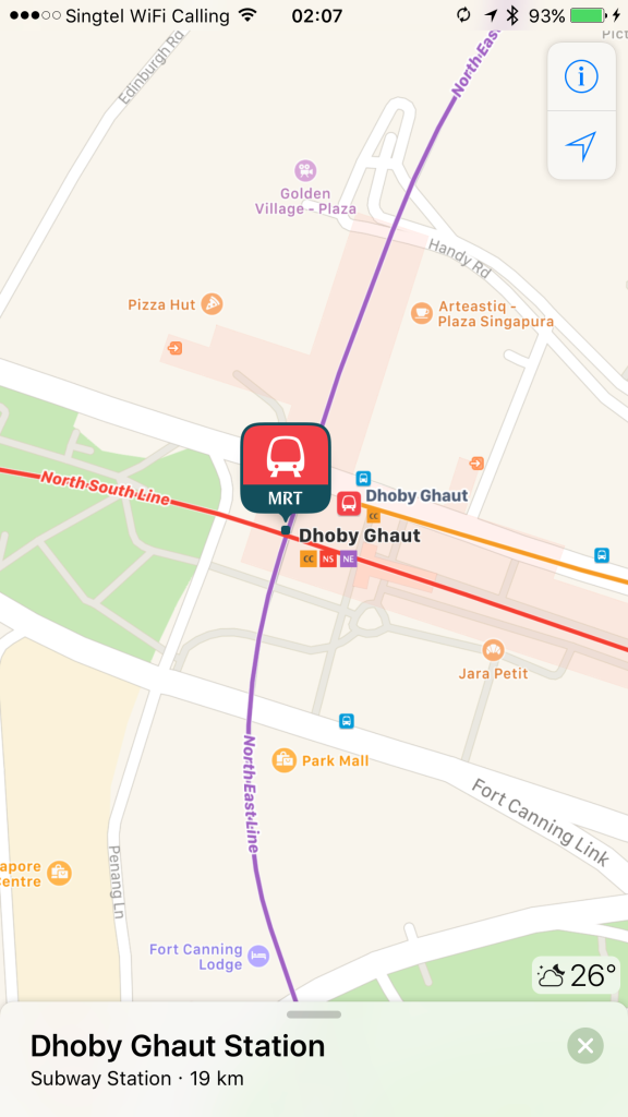
- As some lines, like Dhoby Ghaut has got more than 1 line to transfer to, the next step by step guidance tells which line to change to.
- Shows which platform and train heading for to board.
- Also informing on which station to alight at.


The winning point from using Apple Maps? It shows which exit to take to get to the destination. This makes using Transit much easier if there are a few exits, especially if you are unfamiliar with the area.


The exit info will also indicate which are the ones for the wheelchair friendly users. You can find them with the icon as seen.

Routes with MRT and/or Bus
You can choose your best route to take via MRT and/or Bus which each stating how much you have to walk. The bus routes are usually colour-coded in orange and the MRT lines are in their respective colours.

Detailed view of the route with the exit to take, the bus stop to walk to, the bus number to take, the number of stops before alighting and the name of the bus stop. Or you can use the map view with your current location moving whilst on the bus.


Bus Route Overview


More than just MRT and Public Buses
The Transit info in Apple Maps does not stop just at the major public transport services. It includes info from other companies that are also commonly used by the public and tourists as well, such as the Sentosa Express, Singapore Cable Car, Sentosa Express and Changi Airport’s Skytrain, with frequency included at each of the station or stop.


These enhancements brings more information and transportation options to get from one place to another, in which Google Maps only features Sentosa Express but not the rest as mentioned and the frequencies of the services.
Thanks Chris on this one!
Conclusion
Initial use of the Transit info with Apple Maps has been great so far. The little things and the level of details that Apple puts into the Maps app, such as icons and fonts used for the MRT station, bus stops, exit signs and etc. is just great! An effort to bring local context into the Maps app.
The frequencies at each station or stops is a huge plus, especially if there is a rush for time. I believe if Apple is able to get the data for the exact timing of the buses and trains, it will be replaced by frequencies.
The Apple Maps may need more data information to have a better algorithm for the fastest way or lesser transfers needed. We definitely can see this when more users starts using Transit Info.
Do let us know if you would try Apple Maps for transit or still using Google Maps in the comments section down below!
